


The Waterways of Wamboin
by David McDonald [02-Apr-26]
One aspect of Wamboin’s local history is the waterways of Wamboin: where they are and the origins of their names. Wamboin is not renowned for its waterways, but what we have are important parts of our landscape. Furthermore, some of their names reflect both the almost 200 years of European exploration and settlement here and, less prominently, the possibly 2,000 generations throughout which Aboriginal people were the custodians of the country that we call Wamboin.
Here we present information on the waterways of Wamboin. The Wamboin Community Association will welcome any information that you can provide that will fill any of the gaps or correct anything that is mistaken. Contact the author, David McDonald, ph. 02 6238 3706 or 0416 231 890, email david [at] dnmcdonald.id.au.
For the purposes of this listing, Wamboin is taken to be the locality of Wamboin, not the parish of Wamboin. This is because Wamboin straddles three parishes, and parts of the parish of Wamboin lie well beyond the boundaries of the locality of Wamboin. The boundary of the locality is shown in reddish dashes on the map in the Queanbeyan-Palerang Regional Council online mapping system. Select the layers Boundaries | Suburbs, and zoom in to Wamboin. The waterways listed are those named on present-day maps, primarily the 2017 editions of the former NSW LPI’s 1:25,000 topographic maps ‘Sutton’ & ‘Bungendore’.
Click on a name to expand or collapse the available information.
Birchams Creek
Birchams (sic) Creek rises near the Denley Drive/Hogan Drive intersection and flows south through Birchmans (sic) Estate, to join the Yass River near the northern end of Merino Vale Drive.
Name Origin
‘Guise’s blocks in the high country [“Bywong” station] were first applied for in 1837 by Stephen Burcher of Liverpool who, although unsuccessful in his bid, is commemorated in “Bircham’s Creek” which, with Kowan Creek, forms the source of the Yass River’ (Lea-Scarlett 1972, p. 14).
Additional Information
Quote from the Sydney Monitor, Saturday 17 September 1836, page 3:
‘NOTICE. THE-following Cattle have been running for some time on Mr. Stephen Burcher’s station at the head of Yass River [.] One Cow, with yellow sides, white back, and belly, branded off side on thehip (sic), U. R. O. ALSO - Two Heifers and a Steer. S. BURCHER. September 17, 1836’.
Stephen Burcher, born c. 1796 (UK), arrived Sydney 1814 as a convict under a life sentence for stealing a horse when he was 17 years of age, granted ticket of leave, lived Liverpool (NSW), died 1838 aged just 42 years (Australian Royalty n.d.).
References
Australian Royalty: a family tree of colonial Australians, their forbears and descendants n.d., Stephen Burcher, internet resource, https://australianroyalty.net.au/individual.php?pid=I62947&ged=purnellmccord.ged.
Lea-Scarlett, EJ 1972, Gundaroo, Roebuck Society Publication, Roebuck Society, Canberra.
Black Joes Creek
The creek rises on the ridge running south from Birchmans Grove and flows north-west to join the Yass River 1 km south of Macs Reef Road, in Bywong. Approximately 2 km of the creek loops south into Wamboin, flowing west from the southern end of Newington Road, Bywong.
Name Origin
Oral history, attributed to the Bingley family whose members have farmed in the area since the 1840s, has it that there used to be an Aboriginal shepherd living in the area whose name was ‘Black Joe’. We have not been able to corroborate this from documentary sources.
Additional Information
The Queanbeyan Age newspaper, Thursday 13 May 1869, page 3, published a notice:
‘AMATEUR CONCERT, in aid of raising funds to pay the remaining debt on the Presbyterian Church, will be held in the ASSEMBLY ROOM OF THE ROYAL HOTEL, GUNDAROO On Friday, the 21st inst., When the following Programme will be strictly carried out…’. One of the items on the program was ‘Old Black Joe’, to be performed by ‘D. S. C.’.
‘Old Black Joe’ is a parlour song composed by Stephen Foster (1826-1864), first published, in the USA, in 1853 (Wikipedia 2018, ‘Old Black Joe’).
Brooks Creek
Brooks Creek rises in the high country—the western edge of the Lake George Range—close to the southern end of Ryans Road. From there it flows north, paralleled by Valley View Lane, crossing under Bungendore Road just south of Clare Lane. It continues north, on the eastern side of Bungendore Road, goes under the Federal Highway at Grove Road and soon afterwards turns west to join the Yass River near the Sutton Road/Shingle Hill Way junction.
Name Origin
Named after Captain Richard Brooks, the first large landholder in the Bungendore region, who initially occupied the area in about 1823-1824. Born in Devon, England, c. 1765, died Liverpool (Sydney) 1833 ‘after being gored by a bull’ (Proctor 2001, p. 28), and/or his daughter Charlotte Brooks (c. 1811-1885) who inherited a component of his Lake George landholdings located to the south-east of Wamboin (Turalla Station).
Additional Information
‘The pioneer settler in the district was Richard Brooks who in May 1825 was allowed to purchase for £1000 a tract of 4000 acres which he selected “at a place known by the Native Name of Bungandore in the County of Argyle two miles Southwd. of Lake George”’ (Lea-Scarlett 1968, p. 227).
And see Maher 2016, for details on Capt. Richard Brooks and his family.
‘William Moore of Piper’s Hill, Campbelltown, purchased 640 acres at the head of Brooks Creek on the track from Gundaroo to Bungendore in 1838 and for many years lived quietly but industriously on his property that he named Creekborough. He died there in January 1861 aged 84 …’ (Lea-Scarlett 1972, p. 14.).
The creek was first visited by Europeans (Charles Throsby Smith, Joseph Wild & James Vaughan) on 3 December 1820. They camped there that evening on an expedition heading west from Lake George aiming to locate the Yass River, a waterway that had been described by local Aboriginal informants (Lea-Scarlett 1972, p. 2). Their campsite was probably in what we now call Bywong.
Both alluvial and reef gold mining took place along the creek and in the adjoining hillsides, mostly to the north of Wamboin in the southern Gundaroo area, during various stages between the early 1860s and the end of the 19th century.
Brooks Creek, especially its downstream section from near where it turns west, was formerly known as Shinglehouse/Shingle House Creek. This part of the creek was probably the Yass River until the Cullerin Uplift occurred 10-5 million years ago (Finlayson 2008).
References
Finlayson, D. M. (compiler) 2008, A geological guide to Canberra region and Namadgi National Park, Geological Society of Australia (ACT Division), Canberra.
Lea-Scarlett, EJ 1968, Queanbeyan: district and people, Queanbeyan Municipal Council, Queanbeyan, N.S.W.
Lea-Scarlett, EJ 1972, Gundaroo, Roebuck Society Publication, Roebuck Society, Canberra.
Maher, C 2016, Richard Brooks: from convict ship captain to pillar of early colonial Australia, Rosenberg Publishing, Kenthurst, NSW.
Procter, P (ed.) 2001, Biographical register of Canberra and Queanbeyan: from the district to the Australian Capital Territory 1820-1930: with Bungendore, Captains Flat, Michelago, Tharwa, Uriarra, Hall, Gundaroo, Gunning, Collector and Tarago, The Heraldry & Genealogy Society of Canberra, Canberra.
Kowan Gully
Kowan Gully is the most prominent of the headwaters of the Yass River. It rises near the ACT border in the high country south of Wirreanda Road. The official NSW spelling for the waterway/gully is ‘Kowan’, whereas the official spelling for the nearby ACT locality is ‘Kowen’.
Name Origin
‘Larmer records “Kowan Creek” (sic) on his map of the area south-west of Weereewaa (Lake George) in 1837’ (Jackson-Nakano 2005, p. 23).
‘The district of Kowen has been spelt in different ways, including Kowan, Kohan, Coen, Cohen and even Kohn ... A phonological reconstruction of Kowen suggests that it was partially derived from the Aboriginal placename for the area, which was “kuwain”... Kuwin was also the first element of the aboriginal Kuwiniyan, from which Queanbeyan was derived, although its meaning is unknown…’ (ACT Heritage Council 2015, p. 2).
In contrast, Jackson-Nakano (2005, p. 23) suggests that ‘“Kowan” and other spellings may be a corruption of Cohen. JJMoore’s overseer at nearby “Canberry Station” was James Cohen, also spelled Cowen, so there may be some connection between Kowan and all other subsequent spellings for this overseer’s name’.
References
ACT Heritage Council 2015, Background information, Kowen Cultural Precinct (Blocks 16, 30, 60, 71-73, and 94, Kowen), the author, Canberra.
Jackson-Nakano, A 2005, Ngambri ancestral names: for geographical places and features in the Australian Capital Territory and surrounds, the author, [Canberra].
Mill Post Creek
The creek rises in the high country along the ACT border in the vicinity of Mt Cohen, and flows north-east, through ‘Millpost’ station and the Lake George Range, to join Turallo Creek north of the Bungendore Sewage Treatment Plant.
Name Origin
Not known
Additional Information
We are not aware which was named first, Mill Post Creek or ‘Millpost’ station. Furthermore, the origin of the name does not seem to be recorded, nor available in oral histories. It is possible that the creek and property are named after an early post mill (see Wikipedia contributors, ‘Post mill’) in the area, but residents are not aware of any reports of one there. It is also possible that it is named after a locality or farm in the UK from which early settlers came but that, and the post mill possibility, remain speculation. Note Millpost Hill and Millpost Trig Station between Denley Drive and Hogan Drive, and the old property ‘Millpost’ in the Nanima area (Lea-Scarlett 1972, pp. x, 66).
Reference
Lea-Scarlett, EJ 1972, Gundaroo, Roebuck Society Publication, Roebuck Society, Canberra.
Reedy Creek
Two waterways called ‘Reedy Creek’ are found in or close to Wamboin. The one which flows through Wamboin rises near Norton Road at around the 10 km mark, flows north between Norton Road and Weeroona Drive, past the end of Reedy Creek Place, passing under Bungendore Road immediately south of the Bungendore Road/Macs Reef Road junction, and there joins Brooks Creek.
Name Origin
The middle part of its course meanders, as a reedy waterway, through Clare Valley.
Additional Information
The other nearby Reedy Creek rises on the Queanbeyan Fault, at the NSW/ACT border in Kowen Forest, from where it flows west under Sutton Road, and then south, beside Sutton Road, joining the Molonglo River near Pialligo Avenue. This is outside the boundary of Wamboin.
Woolshed Creek
Woolshed Creek rises near Weeroona Drive and flows north-east, under Warramunga Close near its junction with Woolshed Lane, and joins Reedy Creek close to Bungendore Road immediately south of the Bungendore Road/Macs Reef Road junction.
Name Origin
The woolshed after which it is named is found on Woolshed Lane, close to its junction with Macs Reef Road.
Additional information
‘Ray [Murphy] also notes that much of the Wamboin/Geary’s Gap shearing was done in the shearing shed that still stands just south of the intersection of Macs Reef Road and Gundaroo Road [the old name for the current Bungendore Road]. The flocks from the Ryans, the Taylors, the Donnelleys, the Reardons, and from Lumley were brought there.’ Ned Noel, Wamboin Whisper, Sep. 1997, p. 16.
Stony Creek
Stony Creek rises on the ridge to the west of Birchmans Estate. It then flows north-west to join the Yass River near ‘Woodfield’ station.
Name Origin
Presumably named after the rocky nature of some of the terrain through which it flows.
Yass River/Boongaroon
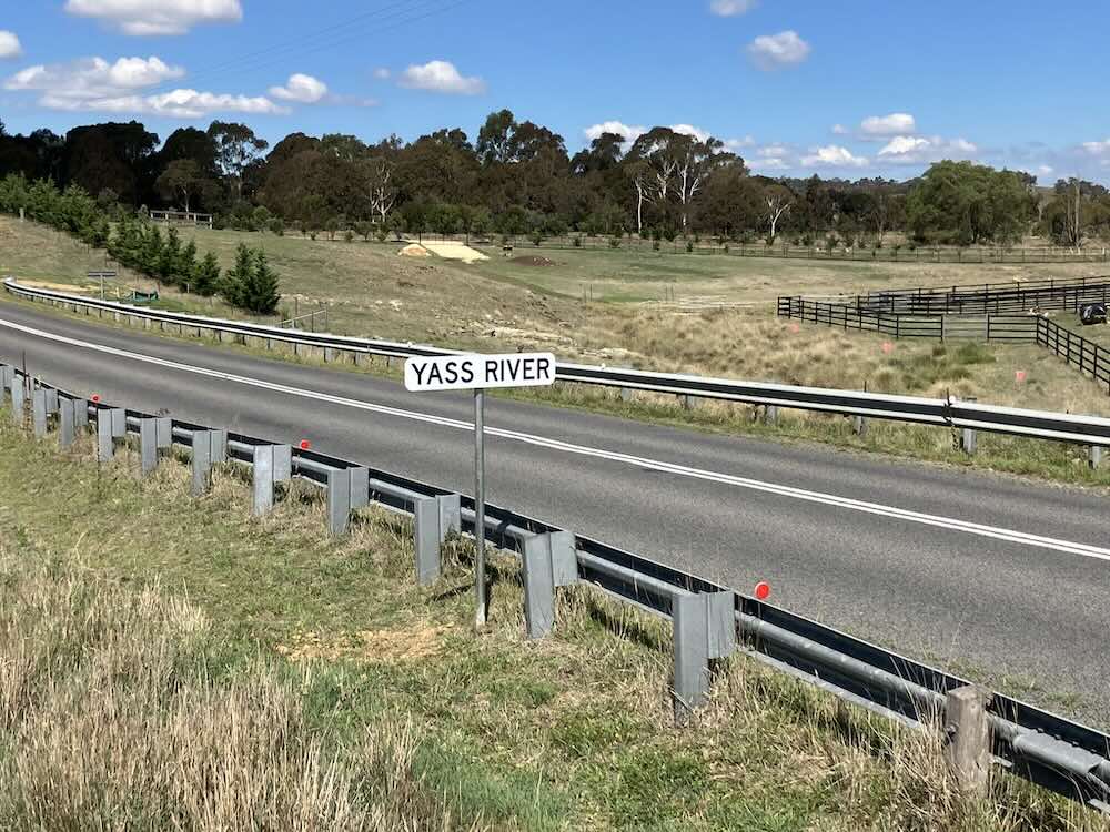
Yass River/Boongaroon at Wamboin, and its Signage
The Signage
Never let it be said that any rivalry or jealousy exists between the localities of Wamboin and Bywong! I have long been uneasy, however, about the signage on the Yass River in our area. Bywong’s Macs Reef Road bridge over the Yass River, built in 1994, contains ‘Yass River’ signs at each end. However, some 18 kilometres upstream, where the river passes beneath Wamboin’s Norton Road via a culvert built in the late 1980s or early 1990s, close to the Norton Road/Wirreanda Road intersection, no such signage was to be seen!
In November 2025, at my suggestion, the Wamboin Community Association (WCA) wrote to the Queanbeyan-Palerang Regional Council requesting that Yass River signage be installed at the river’s Norton Road crossing. Despite follow-up emails, nothing was heard from Council. However, in early March 2026, ‘Yass River’ signs appeared—almost miraculously—at each end of the crossing! The WCA wrote to Council thanking them for installing the signs.
The Yass River
The Yass River is the principal watercourse of the Wamboin/Bywong district, along with Brooks Creek. They have both physical and historical significance in the landscape.
The Yass River rises in the high country near the ACT border, in Kowan Gully (Cohen Creek on some colonial-era maps), south-west of Wirreanda Road. It flows northward beneath Norton Road, then west and north, forming the western boundary of the Parish of Wamboin. The river’s 90 degree turns immediately north of the Norton Road culvert, and near the end of Fernloff Road, are remarkable components of the geomorphology of our area. The fascinating paleo-history of the ancient Yass River, the elevation of the Cullerin Horst, and the course of Brooks Creek as it proceeds to join Yass River between Sutton and Gundaroo, warrants a separate telling (Barrow 2012, chapter 1; Taylor 1907).
From the end of the Fernloff Road extension, the Yass River continues north and north-west to Yass, joining the Murrumbidgee River within the impounded waters of the Burrinjuck Dam.
For Wamboin and Bywong residents, the river is a familiar feature. For historians, however, it presents a more complex problem: what was it originally called, and how did the somewhat strange name ‘Yass’ arise?
Early European encounters (1820)
The river first entered the written record during the colonial expeditions of 1820, when Europeans began probing south-west from Lake George in search of the Murrumbidgee.
In October 1820, a party led by Charles Throsby, accompanied by Joseph Wild, James Vaughan, and two Aboriginal men (possibly Taree and Peroa, neither being from the region (McDonald 2023, pp. 206-7)), crossed the range west of Lake George—very likely in present-day Wamboin—and encountered the headwaters of what is now the Yass River. They followed the stream northward for some distance before returning to their base camp where Taylors Creek enters Lake George, via Brooks Creek and Gearys Gap (Mayer 2000).
A further expedition in December 1820 again traversed this country, confirming the presence of a north-flowing river—now known as Yass River—rising near the Lake George basin. These journeys represent the first documented European contact with the Yass River system in the Wamboin district.
Boongaroon: the earliest recorded name
Significantly, the river was known to Throsby as ‘Boongaroon’: ‘In a letter dated November 17, 1820, Throsby, under directions from the Governor, instructed Charles Throsby Smith, Joseph Wild, and James Vaughan, as follows :-“To proceed to Lake George (Wee-raa-wee) from thence you are to take your departure, and proceed to the stream of water (Boon-ga-roon) which I discovered running to the southward”’ (Cambage 1927, p. 18; and see Watson 1927, p. 6). Throsby was clearly in error in stating that the river ran southwards; then, as now, it ran towards the north!
Given the October and December 1820 routes—where the expeditioners clearly met and followed the headwaters of the Yass River in what is now Wamboin—it is most plausible that ‘Boongaroon’ relates to those upper reaches, even if the 1820 description is imperfect.
It is also worth noting that the Yass and District Historical Society’s journal is called ‘Boongaroon’. The Society states that ‘Our journal Boongaroon refers to the Indigenous name for the headwaters of the Yass River’ (https://yasshistory.org.au/boongaroon/).
The name ‘Yass’: competing explanations from the Yass Valley region
The modern name ‘Yass’ is widely accepted as being of Aboriginal origin, but its precise derivation remains contested. Three main explanations appear in historical sources.
1. ‘Yarrh’ – the original river name?
Early records suggest that the river further downstream from Wamboin and Bywong was called something like Yarrh or Yharr. Linguistic analysis indicates that this may reflect an Aboriginal word ending in a trilled ‘r’ sound, difficult for English speakers to reproduce. As noted by linguist Harold Koch (2009, p.132), early writers such as Hume and Hovell rendered this sound as “rrh”, producing forms such as Yarrh. Later simplification likely produced ‘Yass’. Mowle (1896, p. 24), skilled at Aboriginal languages, similarly suggested that Yass should be ‘Yarr-r-r’.
2. A descriptive Aboriginal term (‘waters’)?
Some sources (notably McCarthy 1952, p. 18) claim that ‘Yass’ means ‘waters’. However, McCarthy himself acknowledged that many such attributions were speculative, and this interpretation is now treated with caution.
3. Anecdotal colonial explanations
According to the Geographical Names Board of NSW, popular stories attribute the name to an Aboriginal guide telling Hume ‘Yass boss, plains’ (1821), or a settler, Mr Angel, saying to Hume ‘Yas, yas, plenty of clear country here’ (1824). These explanations are almost certainly folk etymologies, reflecting later attempts to rationalise an unfamiliar word.
Conclusion
The Yass River carries a layered history:
- a physical presence shaping the Wamboin and Bywong landscape
- an early exploration route in 1820
- an Aboriginal name for its headwaters, Boongaroon, recorded but not securely identified, and
- a modern name, ‘Yass’, derived from an Aboriginal word from the Yass Valley region whose original pronunciation and meaning remain obscure
Taken together, these strands illustrate a broader pattern in south-eastern Australian history: the partial survival of Aboriginal placenames, filtered through early European hearing, spelling, and reinterpretation.
Note: a shorter version of this piece was published in The Whisper, April 2026.
References
Barrow, G 2012, ‘Magnificent’ Lake George: the biography, Dagraja Press, Canberra, A.C.T.
Cambage, RH 1927, ‘Early exploration From Sydney to Canberra’, The Federal Capital Pioneer Magazine, 20 August 1927, http://nla.gov.au/nla.news-article66351235.
Koch, HJ 2009, ‘The methodology of reconstructing Indigenous placenames: Australian Capital Territory and south-eastern New South Wales’, in LA Hercus & HJ Koch (eds), Aboriginal placenames: naming and re-naming the Australian landscape, ANU E Press, Canberra.
Mayer, W 2000, 'In search of a "considerable river": retracing the paths of the early explorers to Lake George, the Limestone Plains and the Murrumbidgee', Canberra Historical Journal, no. ns 45, pp.15-24.
McCarthy, FD 1952, New South Wales Aboriginal place names and euphonious words, with their meanings, Australian Museum, Sydney.
McDonald, J 2023, Canberra I: from antiquity to the invasion, Sorley Boy, Melbourne.
Mowle, SM 1896, ‘Aboriginal songs and words’, Australian Town and Country Journal, 16 May 1896, p. 24.
Taylor, TG 1907, ‘The Lake George senkungsfeld: a study of the evolution of lakes George and Bathurst, N.S.W.’, Proceedings of the Linnean Society of New South Wales, vol. 32, pp. 325–45.
Watson, F 1927, A brief history of Canberra, the capital city of Australia, Federal Capital Press of Australia Ltd, Canberra.